 | |
| day-05.gpx | Gogle Maps GPX Viewer |
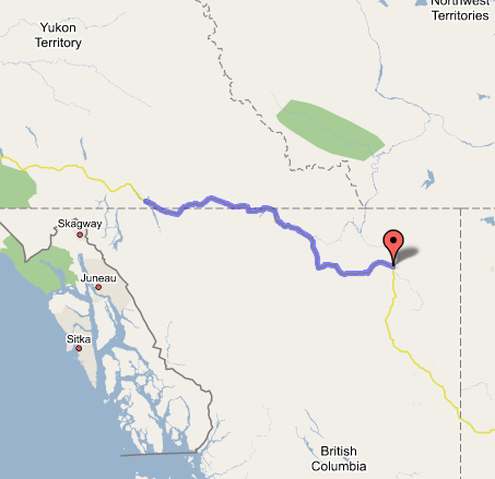
Fort Nelson, BC to Teslin, YT
Woke up refreshed and ready for a day of exciting scenery and sights. Got gas ($1.13/liter—way too much!) and went to the Overwaitea Foods supermarket to pick up some peaches and sour apple Crush for breakfast with our Nutri-Grain bars. I was very impressed with the grocery store—every bit as well-stocked as any Safeway in more populated climes, with fresh orchid bouquets and good produce, at decent prices, even. Left Fort Nelson with these purchases around 9:00, after bidding a fond farewell to the Ft. Nelson Motor Hotel and its spookily high-class appointments, including the grand old-style tiki atrium and pool area, with real stone steps to the second floor and thick wood balconies for the second-story rooms overhanging the indoor palm trees and breezeways. How can they provide these amenities at $55 a night? Why were there no more than two other parties staying? Who would pay $139 for the Super 8? Who knows. My current theory is that it's haunted, and if anyone were to go back there today, "Chris" would exist only as a thin, cackling voice carried by the wind through the vacant lot where the hotel used to stand back in the early 60s.
Anyway, we stopped at the turnoff to the Liard Highway where we'd driven about 5 miles the previous night, because I wanted to get a timer shot of the two of us in front of the "Discover the Northwest Territories" sign next to the turnoff. As I was setting up the shot, and Paul and I were getting ready to stand in the foreground some 50 yards from the car (for telephoto composition), a black bear ambled across the road right between us and the car and ducked into the brush near the road signs I was putting in the shot, turned around, and stared at us. I had the shot all set up, so I took a couple—just like the pose I'd meant to get, but with a bear in the background instead of us in the foreground. Unfortunately I only had the 50mm lens mounted, and I didn't want to sacrifice the few seconds it would take to swap in the telephoto lens, so the bear only looks like a small black smudge near the car. He disappeared without incident a few moments later (we were rather antsy getting back to the car, small though black bears are), and we continued on our way.
The road rose within a few dozen miles into striking mountain terrain with exposed granite walls; got many good shots of places like Steamboat and then Summit Lake, at which point we were back in the Rockies, which had veered much further west since we'd last passed through them. We enjoyed the stark sights and arctic sounds and smells at Stone Mountain, the conical peak at the center of a provincial park full of wildlife (caribou and Rock sheep standing in the road and staring at us as we rounded corners), and then descended a Lee Vining-like canyon into mountain valley bottoms with horse ranches and dirt airstrips. Passed Toad River, where we'd thought (briefly) of trying to spend last night—definitely not worth it! Eventually the winding river led into an even narrower and steeper canyon, and then we abruptly left it and skipped into the Muncho Lake canyon. We had seen our first little troop of Rock sheep in Stone Mountain, but now we were treated not only to great views of the stark and forbidding lake (it seemed to exist all in grayscale), but close-up encounters with caribou and large groups of sheep foraging on the road or licking the rocks for minerals. We quickly picked up on the etiquette for flashing your lights to warn oncoming motorists of animals you'd just seen. Drove past several Muncho Lake resorts, some highbrow, some spartan, some derelict, having presumably lost business as tourist traffic inevitably evolved more toward RVs than passenger cars. We saw many huge washes where flash-flood waters sheet out of the almost soil-less mountains and come running down into the lake in any rainstorm. Finally we left the park (about 1:00—rather behind schedule) and rose out of the valley, returning to the world of greenery as we descended into the thickly wooded Liard River valley. After the river crossing on its little suspension bridge, the road was gravel and under construction for about five miles; before tackling that we stopped at the Liard Hotsprings Lodge (right across from the hot springs themselves, which we skipped, contenting ourselves with the 1972 journal's account of Mom & Dad's skinny-dipping) for thick, satisfying cheeseburgers. We also picked up some travel brochures for various places we'd be visiting later, such as Whitehorse and Dawson City. As we left, we exchanged pleasantries with another carload, a couple from the Bay Area heading home from Alaska. What a place to cross paths, huh? Paul went back inside to tell a Subaru's owners that its lights had been left on; inside, he found that another guest had just left his camera in the lodge and was already pulling out of the parking lot. Paul grabbed the camera and chased the departing RV down, returning the camera to its grateful owner. Two vacations saved in one fell swoop!
The clock now said 2:00, so we reluctantly began to let go of our hopes of reaching Whitehorse, as the couple whose travelogue I've been reading (Tim and Shannon) had eaten lunch in Watson Lake (still two hours away), and they'd taken till 11:00 to get to Whitehorse. So we set our sights instead on Teslin. Crossed into the Yukon at a well-marked sign, but the rest of the crossings weren't marked, except for the final one; apparently it's only seven crossings of the border now instead of nine. Got to the Native village of Watson Lake at about 4:00 and gassed up. I got a really unpleasant vibe from the town; maybe it was the ne'er-do-well who hit us up for cigarettes and beer as we fueled among aggressive hornets descending upon the dead bugs still stuck to my car's front end, or maybe it was the woman with the black eye accompanying her husband and kid in the convenience store/shop inside at the Petro-Canada. It may be a perfectly nice town, but it just didn't sit right with me; and after we got some photos at the Signpost Forest and ran into the same leering panhandler we'd met back at the gas station, we were plenty glad to move on as quickly as possible. Just outside town, though, we discovered that the Signpost Forest wasn't the only way travelers had been personalizing the Alaska Highway; now, the Highway made many cuttings into gravel banks, and every single one was covered with messages spelled out in white rocks, very much like in the lava fields on the Kona Coast on Hawaii. The messages in their full density began to peter out after about 50 miles, but we were still seeing them 150 miles west of Watson Lake.
After a couple of bridges under heavy renovation (we had to wait 15 minutes at one), we found the Yukon portion of the Highway to be in very good repair, with very few potholes or gravel patches. Crossed the Continental Divide, and immediately (as we reentered BC) were plunged into another rain squall, almost as though triggered by the border crossing. The trees in this portion of BC were much taller and more substantial than the spindly and oddly dead-looking spruces seen on most parts of the road up to this point; I like to think it's because everything this side of the Continental Divide gets a lot more rain than the north/east-draining hillsides. In any case, we got ourselves all excited about the prospect of staying in Teslin instead of Whitehorse tonight; we figured it would be a piece of cake to do Teslin-to-Fairbanks in two days, and the motels (particularly the Yukon Motel just over the bridge) sounded inviting, though this would be the first time we'd stayed at one of those conjoined motel/restaurants in a tiny village like this—definitely a far cry from the Imagineered lodgings at Fort Nelson or even the cruddier but two-story motel at Grande Cache. So we crossed into the Yukon for the last time (while listening to my brother Michael's "Alaska or Bust Megamix" playlist that he'd sent me), got some great shots of Teslin next to its picturesque lake from a brand-new-looking overlook and kiosk, and crossed the huge bridge just in time to get the LAST room at the Yukon Motel just after 8:00. A friendly young guy from Vancouver (working there for the summer) checked us in, answered our questions, joked with us, and then waited on our table as we ate in the restaurant; Paul had chicken strips and fries (very good fries!), and I had "Klondike-style" perogies—served with caribou sausage. Fantastic! After dinner we watched The Cat Returns on DVD in the room (sparkling bathrooms—perfect fixtures; well worth the $90), followed by long-exposure night photos in the twilight at 11:30 (the sun didn't set until nearly 11:00, far to the north of us). We couldn't get as many shots as I would have liked, as the mosquitoes were out in force; also I managed to drop my 12-24 Tokina lens in the parking lot, but it landed on the lens hood and suffered no real damage. No Internet in this rather spartan (if large) room; settling for a long journal entry and the hope of making it to Tok tomorrow, leaving an easy 200-mile journey for Friday's leg of the trip.