| Saturday, May 22, 2010 |
20:11 - Down the memory hole
|
(top) |
Sometime in late March, Google Earth underwent a major reorganization in its "Places of Interest" layers—specifically the ones that control the labels of things like mountain peaks, lakes, canyons, islands, and so on.
What they did, in fact, was get rid of them.
Needless to say, this didn't go over too well. It's a bitch having feedback forums and a widespread corporate devotion to "openness", I guess; lots of pesky users with an inconveniently easy way to make their voices heard. So they had to do some hasty rejiggering.
On March 19, we made some changes to the Google Earth layers panel intended to make browsing easier, particularly for casual users of Google Earth. While we're excited about our new "Places of Interest" layer, with more descriptive icons, we've heard many complaints from some of our most loyal users and acknowledge that we made some mistakes in this release, which we are working to address as soon as possible. In particular, we realize we have taken away some important features, and we are working on returning those to our users shortly.
We apologize for the inconvenience, and thank you for your feedback.
Matt Holden
Product Manager
Google Earth Team
But as the official discussion forum indicates, this is hardly a comprehensive solution. Puttering about in Google Earth for a bit, with every possible layer turned on, only confirms the disturbing truth: the layers in question might be back, but the content isn't.
For years I could locate almost any mountain in the state of Montana and Glacier Nartional Park.
You could fly low over the park and find the names and location of about 400 different peaks.
A few months ago they all disappeared. The Geograpic Features layer was taken away.
They have finally put the layer back (inside "More").
But its content is still missing.
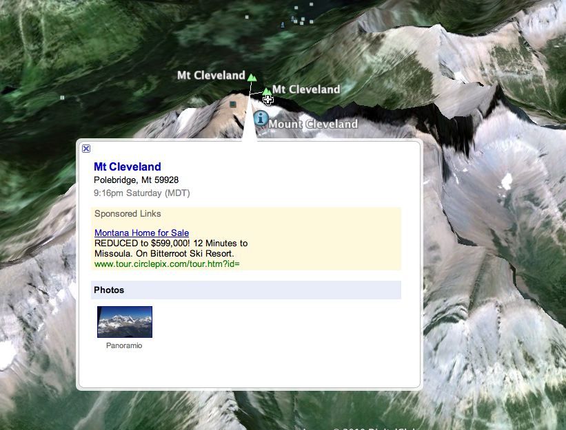
I can only find 1% of the peaks in Glacier National Park, only 4 out of 400 are labeled.
Does anyone know when the content will be restored?
And:
I think the following bears mentioning:
Why would Google go through all the trouble to amass the database with the names of every peak, lake and other geological feature...and then disable it? Can you imagine the effort that went into that!?
Seriously Google...what the hell?
We want the peak names back! The lakes names...the valleys...features...IT USED TO ALL BE IN THERE!
Put it back like it was, please.
It's pretty nonsensical that they'd do this intentionally. Every "official" response from a Google employee in the support forum essentially says the same thing: "Hey, we re-enabled the relevant layers; you'll find them under More. Hope that helps!" —Which pretty much screams "There's more to the story here, but we can't tell you".
My theory is that Google had a, um, data loss event.
I mean, what else could explain it? 95% of the mountain peak data is gone, along with all the lakes, rivers, canyons, and a lot of other stuff. The mountain peaks that are there now are clickable and give you some boilerplate autogenerated junk like the local time and real estate ads and some Wikipedia data if it's available, but that's hardly a consolation; nor are the subtly—dare I say, hastily—redesigned placemark icons for the affected layers.

With all the 3D buildings and other high-density layers that keep getting more and more populous in Google Earth, it's hardly plausible that this was a deliberate attempt to reduce the traffic or memory footprint of the program and its layers. And surely it's obvious to Google just how useful and indispensable the geographic feature labels are to people who use Google Earth for things like hiking, camping, hunting, history, and so on. I find myself thinking the whole "reorganization" thing was just a pretext to cover up a massive and embarrassing database blunder.
I'm not going to make a "don't be evil" reference here. One doesn't always have to ascribe to malice what can be ascribed to incompetence, right?
|
|
 Brian Tiemann