 | |
| day-01.gpx | Gogle Maps GPX Viewer |
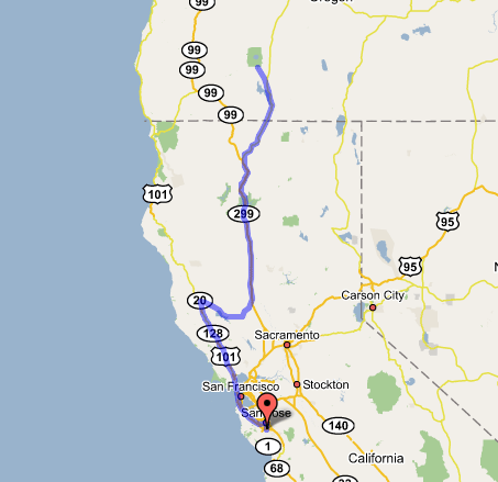
San Jose, CA to Klamath Falls, OR (plus Crater Lake)
We're both pretty tired out after the first day of the trip. Dingy skies made seeing the sights (Lassen, Shasta, etc.) a challenge, but they were there all the same, and the memories from road trips long past came flooding back.
We got a somewhat late start due to Paul's missing luggage, which we'd waited for all evening after he arrived last night, and which threatened to start the whole journey off on a sour note; but this morning we swung by the airport, and the suitcase was there on the first flight of the day from LAX, which had just landed. So that was probably a good omen, or at least we were inclined to see it as such. Then it was a nice and uneventful drive up the coast—we took 280, as per my plan, which held that if it was a clear day in the Bay Area we'd do 101 (because you could then see across the bay), and if not, we'd take 280, which is scenic in any weather; it just so happened that yesterday and today were the smoggiest days I'd ever seen in the South Bay in years. Small wonder I was looking for good omens. But this being a Saturday morning, there was little traffic, and as the city fell away so did the grimy air. We reached Redwood Valley at about noon, where Mom and Dad had a lavish "braunch" (brunch + launch) waiting for us, as they made an appropriately big show of the send-off on a trip they said they wish they were doing (again) with us. The spread filled us both up for the rest of the day. We realized as we parked that we'd (okay, I'd) neglected to pack the two sleeping bags and pads that my parents had already left with me for the trip, so we had to wheedle another pair of sleeping bags out of them—no pads, though, so we hoped we'd land on smooth ground if we ever end up camping this trip. We also practiced setting up their tent, which we stowed in the trunk along with the other rapidly accreting supplies.
We set off again before 1:00, turned east on Highway 20, and gradually left my youth's stomping grounds behind, pointing out all the sights (Lake Mendocino, Blue Lakes, Clear Lake, Mt. Konocti) as we went. At Williams we turned onto I-5 northbound. The Central Valley was full of the same kind of grimy air that we'd left behind in the Bay Area, so we couldn't see Mt. Shasta until Redding, and Mt. Lassen was similarly hidden. Got gas in Redding, where the temperatures read well over 100; picked up some big drinks to tide us through the afternoon. As the highway rose into the mountains south of Shasta, the skies cleared, and the mountain peeked into view down narrow canyons as the highway wound its way toward it; we got off at vista points here and there to grab photos of it (Paul hadn't seen much in the way of big mountains before—this was only the beginning of the trip, and already it was impressive!). Black Butte, the cinder cone that the freeway winds around, was especially fascinating, as it always is to me.
At Weed we left I-5 and joined US 97, the highway that—if we were to follow it all the way north, over the border, and on for as long as it's called "97"—would become the Alaska Highway and carry us all the way to Fairbanks. Our plan is to leave it north of Kelowna and rejoin it at Dawson Creek, but other than that it's this highway from here on up. We greatly enjoyed the first part of 97 north of Shasta, as it wound its way around the foot of the mountain through barren, sagebrush-strewn volcano country, and we stopped for more photos of the mountain at opportune vista points; then the area became a little more run-down as we crossed into Oregon and entered rather confused farming/industrial country. We reached Klamath Falls and checked in at a Quality Inn in the quaintly old-timey downtown—a smoking room (all that was left), but it was in an elbow of the building and very large. We kinda wish (after the fact) that we'd held out for a motel somewhere along the road to Chiloquin and Crater Lake, as there were several that we noticed along our side trip that we undertook—as long as there was sunlight, I wanted to be sure not to pass this near to Crater Lake and not see it. The highway wound around Upper Klamath Lake with some very tight turns and a huge escarpment that I recognized immediately from the satellite maps, then turned off at Chiloquin and forged through tall pine forests for some thirty miles more before entering the Crater Lake park, which we did just as the sun was setting; this gave us enough time to get some rather hurried photos, but also the opportunity to see the lake at sunset, something I wouldn't have seen under other circumstances, namely if Crater Lake were the main attraction of the day.
After sunset (once the photo-taking light was all gone), we got back in the car and headed back to Klamath Falls in the deepening dusk. As I should have foreseen, huge clouds of bugs along the edge of Klamath Lake embedded themselves in our radiator and coated the windshield, to the point where driving became a real challenge, not to mention the disconcerting sound of bugs clustering so thickly it sounded like rain on the car. We ate at an Applebee's north of town, where I found that the usually just-about-right amount of food in their entrees was enough to completely vanquish me by the time I was barely halfway through my steak wrap. This always seems to happen to me on vacation—my appetite shifts down into some sort of screen-saver mode. Then we had a bit of a time finding our way back to our motel; downtown was oddly elusive from the north (and through a bug-coated windshield), and we meandered many blocks through the urban sprawl before somehow finding ourselves back on familiar ground and spying the Quality Inn once more. Back in the room, we downloaded the track log (almost 700 miles this first day) and photos to the borrowed iBook—the geek toys all seem to work fine, against all odds. Turning in now—it'll be a long day of driving tomorrow!